Utilizing Remote Sensing for Water Availability Assessment
Aditya Abhinav, Rahul Kumar, Amit Kumar, Nikhil Singh
MBA in Agribusiness first semester, Sam Higginbottom University of Agriculture, Technology and Science, Prayagraj-211007, Uttar Pradesh
Abstract
This article presents an assessment of the state of Remote sensing for water availability. The management of water resources is a pressing global concern, and proper monitoring of water availability is crucial for sustainable development. Advancements in Satellite and remote sensing technology have significantly transformed the monitoring and management of water resources. This page describes the various satellite-based methods used to monitor water availability, highlighting their benefits and drawbacks, while also discussing the current state of this area of study. Furthermore, the text explores how satellite data can be integrated with additional data sources like ground-based measurements and hydrological models.
Introduction
Across the world, freshwater makes up around 2.5% of Earths total water. Around 30% of this freshwater is stored in underground reservoirs, while the remainder exist in ice caps and glacier waters (69%), snow and ice (1 %), surface water bodies (0.30%), soil (0.05%), and the atmosphere (0.03%). There are roughly 23 million km3 of ground water is present within the upper two kilometres of the Earth's surface, of which 5 million km3 are modern (Gleeson et al., 2016). Satellite, data and hydrological models can improve water availability monitoring. This approach facilitates the collection of space-based data concerning lakes, rivers, groundwater, snow cover, and glaciers. Satellite data calibration and validation can improve these models (Ogilvie et al., 2018). Satellite data combined with ground observations and hydrological models will improve water availability monitoring. When climate change impacts water supplies, more advanced and detailed monitoring systems will be necessary to safeguard these resources.
Remote Sensing Techniques for Water Availability Monitoring
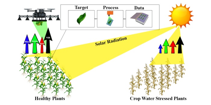
Remote sensing technique play a crucial role in monitoring water availability over large distances. To ensure accuracy, remote sensing relies on ground data for calibration and validation of its spatial and temporal resolution. Various sensors have been employed for water availability monitoring, including:
- Optical sensors: These sensors measure visible and near-infrared radiation from Earth's surface. Sentinel-2, MODIS, and Landsat are some examples. Optical sensors are utilised assessing surface water, snow cover, and evapotranspiration indices. These methods assess the reflectance of water bodies and their surroundings using visible, near-infrared (NIR), and SWIR wavelengths.
- Thermal infrared sensors: Thermal infrared sensors can detect subsurface water sources or changes in water flow by measuring plant or water body temperatures. Notable examples are the Thermal Infrared Sensor (TIRS) on Landsat and MODIS.
- Microwave sensors: Beneficial microwave sensors monitor reservoir levels, soil moisture for irrigation, floods warning, and more using Earth's natural microwave radiation. Examples include the Soil Moisture and Ocean Salinity (SMOS) and Soil Moisture Active Passive (SMAP) missions.

Fig-01 Water Remote Sensing
Pros and Cons of Satellite Monitoring for Water Availability
Pros:
a. Satellite monitoring can detect water availability in large, distant, and inaccessible places.
b. Satellite monitoring provides real-time water availability data, which is crucial for water resource management, especially during droughts.
c. Satellite monitoring of water availability is cost-effective since it doesn't require ground-based equipment and personnel.
d. Satellite monitoring offers trustworthy data for water management choices.
Cones:
a. Satellite monitoring might not offer the same level of details of ground-based methods when assessing water quality.
b. Clouds and fog can reduce satellite signal accuracy.
c. Satellite data interpretation expertise may be hard to get.
d. Satellite sensors might not affectively capture groundwater replenishment or subsurface stream flow.
Using Hydrological Models and Other Data Sources to Combine Satellite Data
Satellite data is frequently utilized in conjunction with hydrological models and ground-based observations to assess water availability. Data assimilation, model calibration, and multi-sensor fusion integrate data. Hydrological models simulate water behaviour and movement (Zhang et al., 2022). These models can integrate satellite data with ground observations to get a more accurate picture of water availability.
Satellite data can be effectively combined with hydrological models. Ground-based soil moisture, groundwater levels, and streamflow observations serve to validate satellite data and enhance the accuracy of water availability estimates. Satellite data can help water managers and academics understand water availability and distribution (Brocca et al., 2020).
Table 1: Remote sensing is used to design hydrological models on the Indian subcontinent
| S. No. | Hydrological parameters | Study Area | Satellite Data Used |
|
1. |
Level of water and stored underground water | North India, Ganga, Koshi, Sutlej, and Beas River Basin | MODIS, GRACE, TRMM |
| 2. | Water Quality | Beas River Basin, Ganga Basin, Chilika Lake | Landsat, MODIS |
|
3. |
Soil Moisture | Indian Subcontinent, North Region | SMOS, MODIS, SMAP |
| 4. | Snow Cover | Himalayan Region | GRACE, MODIS, Landsat |
| 5. | Precipitation | North Monsoon Region, Indian Subcontinent | IMR, TRMM, INSAT |
MODIS- Moderate Resolution Imaging Spectroradiometer, GRACE- Gravity Recovery and Climate Experiment, TRMM- Tropical Rainfall Measurements Mission, SMOS- Soil Moisture and Ocean Salinity, SMAP- Soil Moisture Active Passive, IMR- INSAT Multi-spectral Rainfall.
Current Research and Future Directions
Climate change, population growth, and urbanization make satellite water monitoring more important than ever. This field's study focuses on improving satellite data processing and water resource monitoring technologies. New sensors and algorithms are being developed to improve satellite data. Combining ground and satellite measurements improves accuracy in other investigations. Another focal point involves utilizing satellite data in conjunction with hydrological model to forecast water availability. The European Space Agency's Water Cycle Multi-Mission Observation Strategy (WACMOS) assesses regional water availability using satellite data and hydrological models. Satellite water availability monitoring will become increasingly important as water resources become scarcer. Global collaboration is needed to effectively manage water resources using satellite data.
Conclusion
Satellites offer a precise means of tracking global water resources. The continuous development of satellite sensors, data processing techniques, and water monitoring technologies, both present and future, will be indispensable for effectively managing water resources within a changing environment. Scientists and water manager rely on satellite to monitor crucial factors like precipitation, soil moisture, surface and ground water, and evapotranspiration in order to secure future water supplies.
References
- Brocca, L., Massari, C., Pellarin, T., Filippucci, P., Ciabatta, L., Camici, S., ... & Fernández- Prieto, D. (2020). River flow prediction in data scarce regions: soil moisture integrated satellite rainfall products outperform rain gauge observations in West Africa. Scientific Reports, 10(1), 12517.
- Gleeson, T., Befus, K. M., Jasechko, S., Luijendijk, E., & Cardenas, M. B. (2016). The global volume and distribution of modern groundwater. Nature Geoscience, 9(2), 161-167.
- Ogilvie, A., Belaud, G., Massuel, S., Mulligan, M., Le Goulven, P., Malaterre, P. O., & Calvez, R. (2018). Combining Landsat observations with hydrological modelling for improved surface water monitoring of small lakes. Journal of Hydrology, 566, 109-121.
- Zhang, Y., Hou, J., & Huang, C. (2022). Integration of Satellite-Derived and Ground-Based Soil Moisture Observations for a Precipitation Product over the Upper Heihe River Basin, China. Remote Sensing, 14(21), 5355.


